Property Record
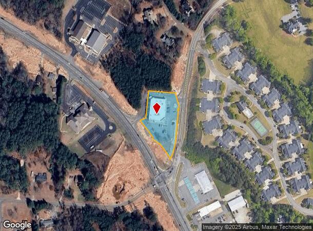
603 Canton Rd, Cumming, GA 30040
NEARBY LISTINGS FOR SALE OR LEASE
Property Detail
603 Canton Rd
Atlanta-Sandy Springs-Roswell, GA
Canton Hwy Bus Dis
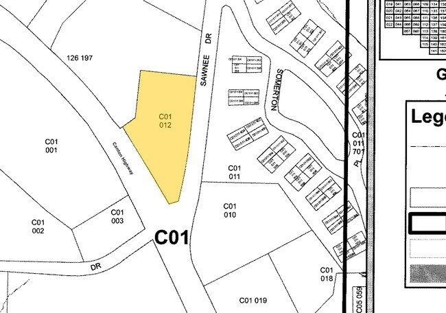
C01-012
3-1 1104
Commercialnec
Forsyth
X
Georgia
13117C0132G
1104
2024
1.52 AC
2025
N Fulton/Forsyth County
130411
Atlanta
14,200 SF
DEMOGRAPHICS near 603 Canton Rd
1 Mile
3 Mile
5 Mile
2024 Total Population
3,719
35,611
107,770
2029 Population
4,335
41,566
125,857
Pop Growth 2024-2029
+ 16.56%
+ 16.72%
+ 16.78%
Average Age
42
40
39
2024 Total Households
1,340
12,498
36,585
HH Growth 2024-2029
+ 16.64%
+ 16.81%
+ 16.86%
Median Household Inc
$81,303
$99,449
$111,942
Avg Household Size
2.60
2.80
2.90
2024 Avg HH Vehicles
2.00
2.00
2.00
Median Home Value
$336,607
$379,527
$414,982
Median Year Built
1995
2001
2003
Nearby Places
Map Layers
Map Styles
 Street
 Aerial
- Restaurants
- Banks
- Shops
- Fitness
- Groceries
Nearby Properties
Address
Land Use
TOTAL SIZE
Lot Size
Zoning
Address
Land Use
TOTAL SIZE
Lot Size
Zoning
10.82 AC
PUD
Address
Land Use
TOTAL SIZE
Lot Size
Zoning
10.57 AC
PUD
Address
Land Use
TOTAL SIZE
Lot Size
Zoning
15,081 SF
27.53 AC
R3
Address
Land Use
TOTAL SIZE
Lot Size
Zoning
208,496 SF
23.61 AC
R3
Address
Land Use
TOTAL SIZE
Lot Size
Zoning
312,095 SF
28.86 AC
PSC
Address
Land Use
TOTAL SIZE
Lot Size
Zoning
15,600 SF
21.98 AC
R3
Address
Land Use
TOTAL SIZE
Lot Size
Zoning
173,374 SF
32.90 AC
CBD
Address
Land Use
TOTAL SIZE
Lot Size
Zoning
6.49 AC
PUD
Address
Land Use
TOTAL SIZE
Lot Size
Zoning
171,065 SF
16.22 AC
CBD
Address
Land Use
TOTAL SIZE
Lot Size
Zoning
24.78 AC
INST
Address
Land Use
TOTAL SIZE
Lot Size
Zoning
62,085 SF
28.70 AC
INST
Address
Land Use
TOTAL SIZE
Lot Size
Zoning
11,737 SF
34.75 AC
A1
Address
Land Use
TOTAL SIZE
Lot Size
Zoning
152,562 SF
12.80 AC
R3
Address
Land Use
TOTAL SIZE
Lot Size
Zoning
159,291 SF
29.19 AC
MU
Address
Land Use
TOTAL SIZE
Lot Size
Zoning
127,940 SF
14.30 AC
HB
Address
Land Use
TOTAL SIZE
Lot Size
Zoning
267,180 SF
31.01 AC
INST
Address
Land Use
TOTAL SIZE
Lot Size
Zoning
111,194 SF
13.53 AC
NS
Address
Land Use
TOTAL SIZE
Lot Size
Zoning
89,562 SF
10.61 AC
CBD
Address
Land Use
TOTAL SIZE
Lot Size
Zoning
268,761 SF
55.50 AC
INST
Address
Land Use
TOTAL SIZE
Lot Size
Zoning
60,392 SF
1.66 AC
CBD
Address
Land Use
TOTAL SIZE
Lot Size
Zoning
95,926 SF
34.26 AC
HB
Address
Land Use
TOTAL SIZE
Lot Size
Zoning
175,237 SF
2.13 AC
CBD
Address
Land Use
TOTAL SIZE
Lot Size
Zoning
104,724 SF
4.83 AC
M1
Address
Land Use
TOTAL SIZE
Lot Size
Zoning
155,804 SF
3.24 AC
CBD
Address
Land Use
TOTAL SIZE
Lot Size
Zoning
175,312 SF
13.59 AC
PSC
Address
Land Use
TOTAL SIZE
Lot Size
Zoning
121,197 SF
1.90 AC
CBD
Address
Land Use
TOTAL SIZE
Lot Size
Zoning
1,752 SF
170.87 AC
A1
Address
Land Use
TOTAL SIZE
Lot Size
Zoning
23,704 SF
3.72 AC
CBD
Address
Land Use
TOTAL SIZE
Lot Size
Zoning
151,580 SF
21.78 AC
MU
Address
Land Use
TOTAL SIZE
Lot Size
Zoning
88,350 SF
10.01 AC
PSC
The World's #1 Commercial Real Estate Marketplace
Connect with us
© 2026 CoStar Group
The information above has been obtained from sources believed reliable. While we do not doubt its accuracy we have not verified it and make no guarantee, warranty or representation about it. It is your responsibility to independently confirm its accuracy and completeness. Any projections, opinions, assumptions, or estimates used are for example only and do not represent the current or future performance of the property. The value of this transaction to you depends on tax and other factors which should be evaluated by your tax, financial, and legal advisors. You and your advisors should conduct a careful, independent investigation of the property to determine to your satisfaction the suitability of the property for your needs.